Robotics built for the first miles of discovery.
Silver Robotik develops rugged autonomous rover platforms for geophysical survey, remote terrain intelligence, and early-stage mineral prospecting. The system is designed to turn difficult ground into repeatable exploration workflows for autonomous mineral exploration and robotic geophysical surveying.
Critical mineral demand is rising while exploration remains terrain limited and manpower heavy.
Electrification, energy storage, and advanced manufacturing continue to intensify demand for critical minerals. Early-stage exploration remains expensive, slow, and difficult to standardize across challenging environments. Autonomous ground robotics enables repeatable survey execution, broader terrain access, and higher consistency in geophysical data acquisition.
Electrification and storage continue to increase strategic demand for mineral supply.
Remote and difficult ground still limits early-stage survey efficiency.
Manual field workflows often produce uneven execution and inconsistent coverage.
Mobility, sensing, autonomy, and analysis become more valuable when designed as one system.
A rover platform designed for geophysical field operations.
The system combines six-wheel mobility, rough-terrain posture, modular payload architecture, and a navigation stack built for remote survey missions. It is designed to support early-stage mineral prospecting where access, repeatability, and sensing quality matter.
Mobility
Six-wheel architecture with rocker-bogie-inspired geometry for mud, loose rock, shallow obstacles, and unstable route conditions.
Navigation
GNSS, IMU, and LiDAR as the core perception stack for route following, terrain awareness, and semi-autonomous survey behavior.
Survey Payloads
Primary direction built around a magnetometer mast, with room for broader geophysical and mapping modules in the same family.
An end-to-end workflow for autonomous exploration.
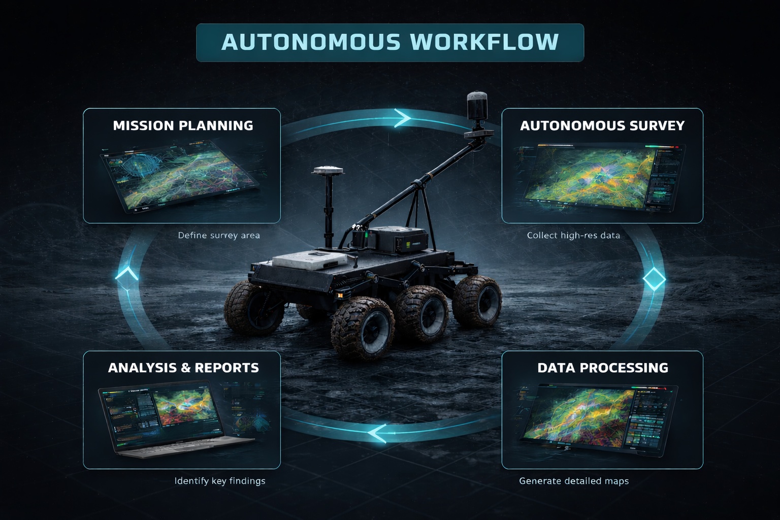
The rover is intended to support a structured exploration process from survey planning through anomaly identification and target refinement.
Survey Planning
Define the target area, survey grid, line spacing, and route logic for the field campaign.
Autonomous Scan
Execute repeatable grid passes across remote terrain with stable positioning and route control.
Data Acquisition
Collect geophysical signals through onboard survey payloads during continuous route execution.
Anomaly Detection
Process survey data to reveal signatures that may indicate mineral-bearing structures or zones.
Target Validation
Prioritize high-potential locations for follow-up work, resurvey, sampling, or drilling decisions.
Built as a system, not only a vehicle.
Silver Robotik combines mobility, autonomy, sensing, and data interpretation into one exploration workflow.
Mobility Platform
All-terrain rover chassis designed for rough field conditions and survey route stability.
Autonomy Software
Mission logic, route execution, mapping, localization, and terrain-aware navigation.
Geophysical Sensors
Magnetometers and compatible survey instruments for early-stage anomaly detection.
Data Pipeline
Processing, visualization, and interpretation of survey outputs to support decision making.
Magnetic anomaly mapping for target generation.
Survey outputs can be visualized as terrain-linked anomaly maps to support faster interpretation and prioritization of follow-up targets.
Technical Overview
Rover platform for remote and difficult terrain.
A single field image emphasizes the rover platform, terrain capability, and survey posture in remote outdoor conditions.
Partner with Silver Robotik.
Silver Robotik is seeking strategic partners, pilot opportunities, and investor conversations around field robotics for mineral exploration and data-driven survey operations.